It is called the 3rd pole of the earth. At 21000 ft , it is a frozen river of ice with temperatures from -35º Celsius in summer to -60º Celsius in winter. Added to this the concealed crevasses, avalanches, spine chilling cold winds all make the place thence north to the glaciers an inhospitable and an uninhabitable piece of realty..
That’s exactly what Major-General S.M. Shrinagesh and his Pakistani counterparts thought when they signed the Instrument of Cease Fire Line (CFL) in1949 at Karachi. Little did they know that in just four more years a key sentinel of Mother Nature’s harshness and hostility, the Mt Everest (29,028 ft) would be conquered.
But... a battlefield at 21000 feet? Well that had to wait for three more decades.
A little geography:
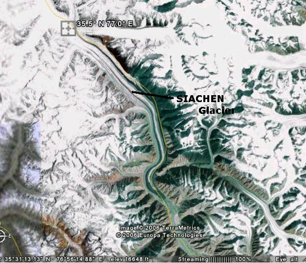
Siachen Glacier is what I am talking about. The word “Siachen” literally/ironically means “Place of Wild Roses” in Ladakhi maybe owing to the wild orchids that grow in the Himalayas. Cartographically Siachen is almost trianglular in shape with NJ9842, Indira-Col and Karakoram Pass as its three corners. The 72 km long glacier, one of the longest in the Himalayas lies between the Saltoro Ridge in the West and the Karakoram ranges in the west. It has number of peaks, side valleys and at its head lies the Indira Col, the divide between South and Central Asia. The glacier feeds the Nubra and the Shyok rivers which ultimately turns into the Indus.
Co-ordinates to view Siachen on Google Earth: 35.5° N 77.0° E (Zoom-out slightly to have a complete view of the glacier) . This is how it looks like :
That’s exactly what Major-General S.M. Shrinagesh and his Pakistani counterparts thought when they signed the Instrument of Cease Fire Line (CFL) in1949 at Karachi. Little did they know that in just four more years a key sentinel of Mother Nature’s harshness and hostility, the Mt Everest (29,028 ft) would be conquered.
But... a battlefield at 21000 feet? Well that had to wait for three more decades.
A little geography:
Siachen Glacier is what I am talking about. The word “Siachen” literally/ironically means “Place of Wild Roses” in Ladakhi maybe owing to the wild orchids that grow in the Himalayas. Cartographically Siachen is almost trianglular in shape with NJ9842, Indira-Col and Karakoram Pass as its three corners. The 72 km long glacier, one of the longest in the Himalayas lies between the Saltoro Ridge in the West and the Karakoram ranges in the west. It has number of peaks, side valleys and at its head lies the Indira Col, the divide between South and Central Asia. The glacier feeds the Nubra and the Shyok rivers which ultimately turns into the Indus.
Co-ordinates to view Siachen on Google Earth: 35.5° N 77.0° E (Zoom-out slightly to have a complete view of the glacier) . This is how it looks like :
Roots of the conflict:
India and Pakistan have fought three wars over Kashmir. In 1949 after the First Kashmir war an agreement which primarily aimed at demarcating the Cease Fire Line (CFL, which subsequently became the LoC after the Shimla Agreement of 1972) between India and Pak was signed by both the countries. As stated earlier in the prelude the demarcation of the CFL unfortunately stopped at a point now known on the maps as NJ9842. Beyond this there was no demarcation. The instrument of CFL just read that the Ceasefire Line would continue thenceforth north to the glaciers.

While India continues the LoC from NJ9842 North-west along the Saltoro Ridge line, the Paki version draws a straight line from NJ9842 to the Karakoram pass. Nevertheless NJ9842 was just another co-ordinate on the map till the late 1970s.
Build-up to Operation Meghdoot:
The whole equation changed in 1977, when Indian Col Narender ‘Bull’ Kumar while leafing through a mountaineering magazine found an article on international expeditions venturing onto the glacier from the Pakistani side. Its like you get up in the morning and there you find a newspaper ad that has put up your house on sale! Now that’s not good.
By late 1970s and early 80s Pakistan had started issuing permits to foreign expeditions; Pak also started showing the whole glacier as a part of its map by drawing a straight line from NJ9842 to the Karakoram pass.
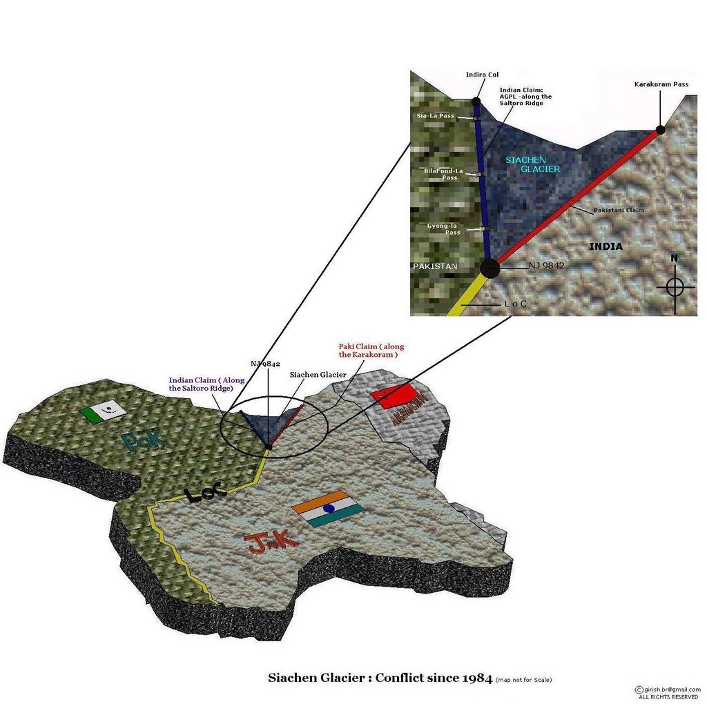
This is very much in contradiction of the Actual Ground Position Line (AGPL) that India draws from NJ9842 North-West along the Saltoro ridge to Indira–Col.
This alarmed India and it sent an affirmative mountaineering expedition led by Col Narender Kumar in 1978. The Indian mission scaled almost all the important peaks of the glacier including the Saltoro-Kangri and also skied down through most of the strategic passes like Bila-Fondla, Saltoro Pass and the Indira-Col. During this mission Indian forces gathered vital geographic intelligence of the glacier which proved to be of great use in the future.
Operation Meghdoot:
The final blow came when Pakistan gave permission to a Japanese expedition to attempt Rimo peak in 1984. This peak is located in the side valley, east of Siachen. It overlooks the eastern areas of the Aksai Chin. Such an expedition would have firmly linked the western routes with the eastern routes, -- the trade route leading to Karakoram Pass and China.
In the summer of 1984, On April 14th to be precise India launched pre-emptive offensives and the armed forces went to the glacier under an operation codenamed Operation MegDoot . Pakistan soon retaliated and marched its forces into Siachen which was followed by a bloody battle to occupy the Saltoro ridge. Within a week India chased the Pakis away and occupied the Saltoro Ridge and the two passes BilaFond-La and Sia-La. Since then Pak launched repeated retaliatory attacks to occupy the heights, but all such attempts were mowed by India.
One such attacks was a ‘celebrity’ attack that came in September1987. A group of elite Pakistani SSG commandos led by Pervez Mushraff ( yes the same one who is currently the Prez of Pak), tried to lay seize on BilaFond-La pass. Mush enjoyed limited initial success. But he and his men were badly beaten back in a daring day-time attack by 8th J and K Light Infantry led by Subhedar Bana Singh.Not only did he re-occupy our posts, he also succeeded in grabbing a Paki post called Quaid. To honor Bana’s exceptional bravery, Quaid post was renamed as Bana-Top!
The last major artillery shelling/gun battle was in Sept 1999. By and large the guns have fallen totally silent since the Nov 2003 cease fire between the two countries. However both the contries have deployed more than 5000 troops on either sides to keep a constant vigil on any mis-adventure that either of the countries may perpetuate.
India can neither come down; nor can Pakistan come up !
Being at a height, India definitely has the tactical advantage over Pak in Siachen. At 21000 ft India can have a close watch on the strategic Karakoram Highway that’s connects Pakistan and China, this according to many defence analysts is definitely a big advantage for India at the time of an eventuality.
All this is fine. But..
Manning your posts at 22000 feet is not a cake-walk.
- It costs India nearly INR 4 crore (approx $1 Mil) per day to maintain . At aprox $ 400 Mil per year it may account to the annual GDP of some of the poorest economies of the world. Pakistan at the same time spends around $0.3 Mil everyday. The difference is mainly because of the heights we control.
- Being at a height is a tactical advantage, but logistically it’s a catastrophe. While Pakistan being in the Siachen valley (at a lower height 10,000ft) can manage to get most of its supplies via road on mules , India has to heavily rely on transport aircraft and Choppers for its supplies. In Siachen an Indian Chapatti costs INR 700 while the same costs Pakistan INR 300 i.e., roughly half of what we spend. In an ironic sense I call that the extra tax we pay to hold a better piece of real estate! This is a real pain for the country’s exchequer.
- Siachen is a battlefield where 80% of the soldiers on either side die of natural calamities like avalanches, frostbites and extreme cold. It’s estimated that one Paki soldier dies every four days and one Indian jawan succumbs to death every second day. Considering the and soldier morale and the high cost that goes into the training/acclimatization of a Jawan, such casualties are definitely unsought for.
But what can be done?
Since 1999 India & Pakistan have had 9 rounds of defence secretary-level talks on the Siachen issue. All failures, Pakistan doesnt recognise the Actual Ground Position Line, we dont recognize their version of LoC extension and so neither of us will pull out. Last June our PM Manmohan Singh visited the glacier , then when he talked about the Siachen Peace park
Siachen Peace Park / Demilitarization: ‘For the Peace Park to happen the region has to be demilitarised first and thats Not so easy’, opines the army. Pakistan cannot be trusted and that too after the 1999 Kargil ‘mis’adventure the mutual trust between the two countries has reached a new low. There has be several small Confidence Building Measures like decreasing the head-count, replacing soldiers with electronic surveillance etc., after which the final demilitarization is possible.
It wouldn’t be so easy for India to walk away from an advantageous position, that too after so much of bloodshed. India fears that Pak may march into the Saltoro Ridge the moment we leave. Electronic/satellite surveillance can just keep a check on who is coming into the Glacier, but again its our jawans who have to shed their blood to drive them back . Mistrust is one motivating factor that keeps the Indians and the Pakistanis in the Glacier.
Conclusion ?
From my current level of reasoning, I am really unable to conclude how exactly this crisis can be ended. But I feel that this conflict cannot be let to go like this forever for these primary reasons.
- It is killing fine young men of our country for no obvious reason ,
- It is boring a hole into our economy and also
- It is ruining the ecosystem of the glacier.
Confounded by the complexity of the situation , for a closing note I chose to leave you with some words that our PM has rightfully said “In the pursuit of peace we cannot accept any changes in the established boundaries, these boundaries are important not only for our security but it relates to the country’s prestige also.”

13 comments:
good analysis, but why should there be a treaty after all?
Being in Siachen Glacier for 21 years the INDIAN ARMY has mastered the art of mountain warfare, even the US want to learn it from us.MIND you, If we come down the glacier Pakistan will come up
FIRST OFF ALL IT WAS INDIAN COWARDS WHICH CAME TO LAND WHICH WAS NOT THEIRS.PAKISTAN ARMY WAS NOT OCCUPING SIACHEN WHEN INDIAN COWARDS OCCUPIED IT.
IF BRAVE INDIAN SARKAR HAD ANY GENTLEMANLY GENES IT COULD HAVE PROTESTED AND NEGOCIATED WITH PAKISTAN.
BUT THEY PREFFERED TO SNEAK IN LIKE COWARDS.
ITS A GOOD THING THAT INDIA IS IN SHIT HOLE IN SIACHIN WITH LINE OF COMMUNICATION VERY BAD AND ROADS EXTINT INDIAN TERRORIST FORCES ARE BEING FUCKED REALLY HARD BY WEATHER AND LABOUR.
AND PAKISTAN SPEND I CAROR AND INDIA 10 COROR PER DAY TO MAINTAIN FORCES
Indian cowards???pak duznt understand "gentlemanly" talk.. only thing it understands is force..how can u sit an talk in a gentlemanly attitude with someone who has come n pitched his tent in ur drawing room??
It wasnt a cowardly act.. its the most daring act..n mind u, all ur forces coudnt move us an inch from Siachen.. ur So called special forces SSG was beaten back by ordinary Indian soldiers..
Ok 10 cr Pakistani Rs.. then I agree. Our Rupee is much stronger.. its around 4 cr/ day.. n v being the 2nd fastest growing economy in the world can sustain such an expenditure..!
giri remember kashmir is a disputed territory
nehru took it to UNO
there is a freedom struggle going on in kashmir
and kashmiri hate india and indian terrorist,rapeist army
i hope you are not one of those indians who love to livein self created paradise away from realism
so how you dare to called a land which is not yours?
go and cheak facts about nature of ur rapeist indian terror malitia
Good work .... Siachen is first step ... freeing POK is next .. jai hind
WHAT ABOUT FREEING KASHMIR,TRIPURA,ASSAM,NAGALAND AND MISORAM
AND THE JHARKAND AREA.
WHEN BHARAT MATA IS GOING TO FREE THESE AREAS AND STOP ITS RAPEIST TERRORIST ARMY FROM PLUNDERING THE PEOPLE WHO WANT LIBERATION FROM IT
good point, india is an expansionist and imperialistic state. do you know its only state in south asia who consider its neighbors its biggest enemies.
indian terrorism knows no boundries. at one side these terrorists terrorise dalits and minorities on the other sponser terrorism in neighborhood take the example of srilanka the most loving and peacefull nation in asia. but india created LTTE and other terror groups similarly indians are traing and sponcering terrorism in tibat,bangladesh,pakistan and in burma.
if we read indian politics we have to conclude india and indians are scum of southasia and the world
really nice read...
lot of good facts with interesting pics.
The bana-top fact is too good..
I totally agree with Manmohan singh on not easing boundries in the name of peace..
i could not read whole thing but this looks like a thesis! amazing!
I totally agree:
Confounded by the complexity of the situation , for a closing note I chose to leave you with some words that our PM has rightfully said “In the pursuit of peace we cannot accept any changes in the established boundaries, these boundaries are important not only for our security but it relates to the country’s prestige also.”
If Pakistan can change the border that was "... running straight up north" ... we just cant trust it. It has a history of being a liar state. Try reading any of its history textbook. It's all aimed at creating Generations of Pakistanis that will hate India. Children of age four are "taught" India is a enemy. I feel sad for them. Kedaar
Hi I'd like to thank you for such a terrific made site!
thought this is a perfect way to make my first post!
Sincerely,
Robin Toby
if you're ever bored check out my site!
[url=http://www.partyopedia.com/articles/farm-party-supplies.html]farm Party Supplies[/url].
I disagree with a many point established in the article but like to comment only this, that INDIA have a good eye on karakoram Highway which connects pakistan and china. please do some googling you can find karakoram highway is 160-KM away from the indra col (deepest indian position to the west). even indian army dont have any control over second highest mountain i.e K-2 which is also located in karakoram range and much away from the indian positions and still pak govt. issuing the permit to the local and foreign mountaineers. yes pak army lost qauid post but as per bana singh(Indian Hero) there were only six pak soldiers who fight for three days and died after engaging with 163 indian soldiers. as per bana sing indian lost near 50 of its soldier due to height advantage of these paki soldiers. one thing which i would like to tell all of u that as per bana singh he was order by the base camp capture these six pakistani soldiers alive but he replay no sir its not possible to get them alive. u feel proud with your heroes and i with my heroes. (you can search on google bana singh interview). Article only shows the indian side of story.
I disagree with a many point established in the article but like to comment only this, that INDIA have a good eye on karakoram Highway which connects pakistan and china. please do some googling you can find karakoram highway is 160-KM away from the indra col (deepest indian position to the west). even indian army dont have any control over second highest mountain i.e K-2 which is also located in karakoram range and much away from the indian positions and still pak govt. issuing the permit to the local and foreign mountaineers. yes pak army lost qauid post but as per bana singh(Indian Hero) there were only six pak soldiers who fight for three days and died after engaging with 163 indian soldiers. as per bana sing indian lost near 50 of its soldier due to height advantage of these paki soldiers. one thing which i would like to tell all of u that as per bana singh he was order by the base camp capture these six pakistani soldiers alive but he replay no sir its not possible to get them alive. u feel proud with your heroes and i with my heroes. (you can search on google bana singh interview). Article only shows the indian side of story.
Post a Comment